
You may heard that Mexico City is one of the largest and most populated cities of the planet. If for any reason you wander about its size, I found a video taken from aboard a commercial flight approaching and landing at Mexico City airport. At 7:30, It covers from rougly the area where I live to land. And yes, it does show the smog layer that covers the city.
https://www.youtube.com/watch?v=NwLX506LE2U
Sizing my home city (Mexico City) visually.
Forum rules
Topics should be about experiences, comments, and observations from our members' personal lives.
Topics should be about experiences, comments, and observations from our members' personal lives.

Re: Sizing my home city (Mexico City) visually.
Mexico City is not only huge, I see by the video that it is also densely populated. Metropolitan Chicago, my home town, stretches from the lake to about fifty miles west. That's not all Chicago proper, but a lot of suburbs too. I've come into O'Hare flying over the city and have always been amazed at it's size. However, it's nowhere nearly as dense as is your home town. I think Chicago has about 3 million people within it's limits and just under 10 million when counting all the collar counties. Mexico City alone apparently has that many people. You live in a beautiful city Juan. It's a place you can be proud of.

Re: Sizing my home city (Mexico City) visually.
and here's where my roots are from, 'hugely' developed since i left in 1960:
https://www.google.ca/maps/place/35300+ ... 24.3574084
the entire country only has some 5.5 mil people on its 338 000 sq km's.
incidentally, the land mass has increased 1000 sq km's since i went to school as it's still rising from the sea since the last ice age. about 1 m/century, if i recall correctly.
Re: Sizing my home city (Mexico City) visually.
I guess it's bigger than when you lived there, but around here that would be a small town. 
I find it interesting that the landscape is "rising" instead of disappearing due to changes in sea level. It seems to be the reverse of what's going one elsewhere in the world - except Hawaii, of course.
I find it interesting that the landscape is "rising" instead of disappearing due to changes in sea level. It seems to be the reverse of what's going one elsewhere in the world - except Hawaii, of course.
Re: Sizing my home city (Mexico City) visually.
oh, it's much bigger now, our house was on the edge of town, now it sits in the subdivision. there was nothing between the church and the lake, that's now loaded up, too. if it's not houses, it's new roads. this is a shot from 1960, centre town:
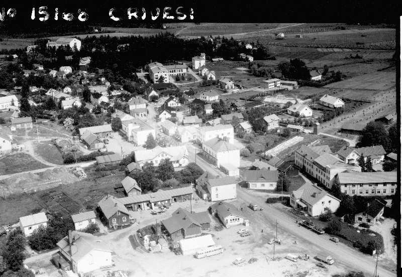
unfortunately, not photoshopped, lol!
unfortunately, not photoshopped, lol!
Re: Sizing my home city (Mexico City) visually.
It's excellent as it is and needs no post processing. From this perspective it looks like a table top model and not anything life size. Funny how cameras can do that.
Re: Sizing my home city (Mexico City) visually.
quite the difference to mexico city, for sure!
the only reason i'd like it a bit sharper is that i can't quite make out what i'm looking at, as i'd actually never looked at the place from this angle.
the only reason i'd like it a bit sharper is that i can't quite make out what i'm looking at, as i'd actually never looked at the place from this angle.
Re: Sizing my home city (Mexico City) visually.
It doesn't look sharp to you?  hmmmmm
Re: Sizing my home city (Mexico City) visually.
that quite washed out part in the middle,
can't read any names on store fronts.
can't read any names on store fronts.
Re: Sizing my home city (Mexico City) visually.
Ohhhhhh. I see. Or, rather, don't see. If we had the original I am sure we could bring out the details. Have you tried Google Maps Street View, or some such program?
Re: Sizing my home city (Mexico City) visually.
google maps would work, but seemed too much bother for a matter that doesn't. the buildings and streets have all been changed since then. but then i thought, why not, and look what i found:
https://www.google.ca/maps/place/35300+ ... 24.3574084
look right in the middle of the screen.

https://www.google.ca/maps/place/35300+ ... 24.3574084
look right in the middle of the screen.
Re: Sizing my home city (Mexico City) visually.
this was the theatre where i saw my first plays and ballets. notice the air raid siren sitting on top; in my days it was used as the alarm to call in the fire fighters.
https://www.google.ca/maps/@61.6793436, ... 312!8i6656
https://www.google.ca/maps/@61.6793436, ... 312!8i6656
Re: Sizing my home city (Mexico City) visually.
I think it's simply amazing that a person could travel literally anywhere on earth and not have to go any further than their computer. The next version of those maps will likely use augmented reality wherein you will wear goggles and have a three dimensional interactive view.
Re: Sizing my home city (Mexico City) visually.
well, the street view is good enough for me. would prefer it to be a bit more up to date though. like, this decade...
that way i could see how the birches i planted at the cottage are doing.
that way i could see how the birches i planted at the cottage are doing.
Re: Sizing my home city (Mexico City) visually.
Virtual reality will cover that, I'm sure. As of today military satellites can zoom in on the details well enough to see how the fruit is growing on your loganberry plant. At the moment mere civilians are not allowed such high quality GPS, but it's just a matter of time. The technology already exists. The only problem is getting the real time updates loaded into a database somewhere. If anyone can do it, Google has the resources to make it happen.